THIS IS THE OFFICIAL WEBSITE FOR
JERRY T. DICKEY dba THE SOLID ROCK
PREHISTORIC INDIAN ARTIFACTS AND AUTHENTICATION ARCHAEOLOGY SECTION
SECTIONS
![]()
| A. BASIC
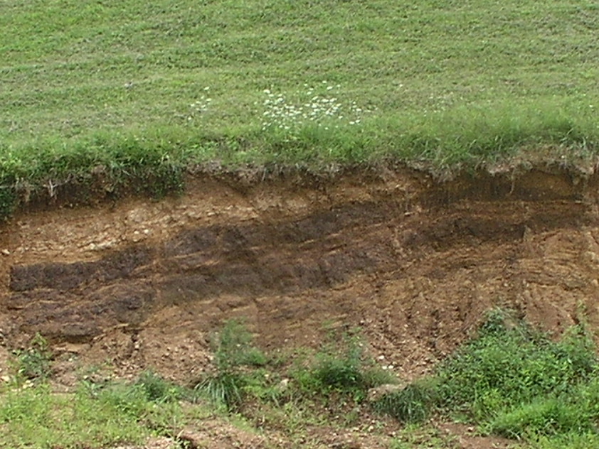
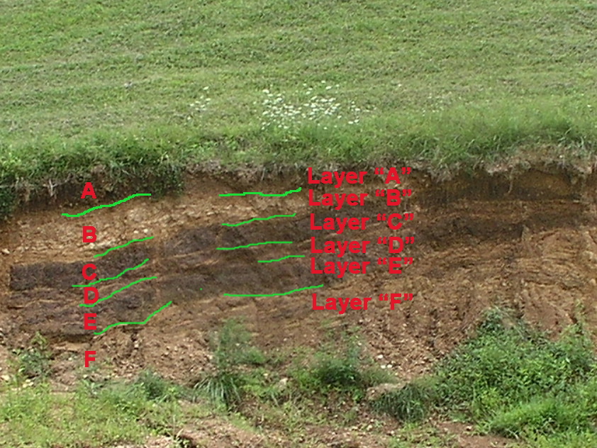
CONCEPTS OF ARCHAEOLOGY - ARCHAEOLOGY DEFINED MY DEFINITION OF ARCHAEOLOGY - Archaeology is the systematic collection and analysis of human remains for the purpose of discovering information about past cultures. Archaeology, in the romantic sense, is the excavation of prehistoric remains of the "ancients" such as Egyptian mummies, Cave Men, etc. For those of us in the U.S. it's the pursuit of knowledge of the ancient American Indian cultures and their ancestors. Archaeology also includes what has evolved into a growing segment of interest in the exploration of historic remains for the purpose of illuminating more clearly the lifeways and in many instances specific information about known people or events. Historic Williamsburg in Virginia is one of, if not, the premier example of historic, Colonial period, archaeology in the U.S. THE ARCHAEOLOGICAL RECORD - Any tangible remains are a part of the archaeological record. This includes all manmade tools, human remains, trash, or other debris left at residential, burial, ceremonial, or manufacturing areas generally known as a "site". It is how we treat the archaeological record that determines if information left by previous peoples is preserved or destroyed and to what extent this information is available for interpretation. From a technical standpoint the archaeological record can be divided into two categories. The first category would include artifacts in primary context. That is to say, artifacts that were left by someone in the past that still resides in the ground, untouched since abandoned by it's user. The second category would include all remains removed from their original place of deposition. These items would include artifacts found in areas disturbed by plowing, flooding [erosion], or other earth moving activities for agriculture or construction. It would include artifacts dug from cultural deposits, irregardless of who or why excavations were conducted. B. BASIC CONCEPTS OF ARCHAEOLOGY - PRESERVATION CONCEPTS OF PRESERVATION - For the professional archaeological community the concept of preservation is simple - don't dig. The theory that seemed to come to maturity in the 1970's in the archaeological community was that of the preservation of any site not immediately threatened by construction or other causes of disturbance. Therefore, if a site is not in immediate danger it is considered better to leave it alone. Of course preservation by protection, such as state or federal site ownership is the ultimate level of control. Another consideration is the development of new technologies. The implication is that the longer a site is preserved the better the potential for retrieving additional information based on better techniques and technologies. While archaeological techniques and information recovery methods have progressed, no doubt that natural forces including acid rain has accelerated the deterioration of "preserved" sites. SALVAGE ARCHAEOLOGY - When sites are in danger of destruction and emergency excavations must be implemented this is called "Salvage Archaeology". Even most sites that are excavated are only partially dug due to budget restraints. Additionally, those sites excavated are generally those located on properties where federal monies are being used for construction activities. The excavation of sites located on private property is given only a passing nod by the archaeological community since there rarely are funds to pay for scientific exploration. C. BASIC CONCEPTS OF ARCHAEOLOGY - HOW DATA IS COLLECTED AND INTERPRETED STRATAGRAPHIC LEVELS - The underlying basis for relative dating is related to the build-up of both natural and manmade deposits over time. The standard assumption is that artifacts nearer to the top of the ground are relatively younger in age than items found deeper in the ground. A number of factors can contribute to the deposition of materials including river silting (flooding), hillside erosion, and human occupational refuse build-up. In cases where sites are occupied year round or for significant periods of time for many years, the resulting deposits of refuse (trash) can range from a foot thick to nearly ten feet thick - sometimes thicker. These dense deposits are normally recognized by black greasy soils called middens. Middens are a mixture of charcoal and fire cracked rock from cooking hearths, decomposed animal and vegetable matter, and in many cases shellfish remains. When sites are occupied by a single cultural group for only a few years, the site is referred to as a single component site. The significance of single component accumulations is the clarity of cultural materials. In other words whatever point types, pottery styles, or other artifact types found in sufficient frequency are almost guaranteed to belong to a single culture who occupied the site. Sites occupied over longer periods of time, by two or more cultures, are termed multi-component sites. Multi-component accumulations are useful in developing cultural sequences in an area or region. Since there is no guarantee of continuous occupation by all cultures, it is the comparisons of findings from several multi-component sites that is generally needed to confirm the complete record of cultural sequences in an area. Here's a photo illustrating natural build-up of layers that is known as Stratigraphy.
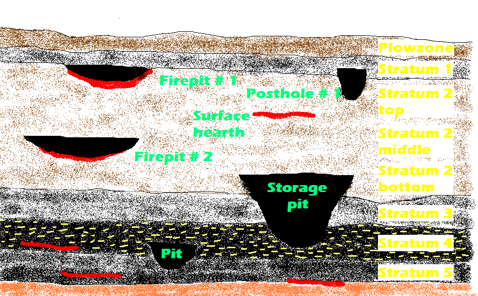
PROBLEMS INTERPRETING STRATIGRAPHY - In a perfect world everything would work in practice as well as in theory. Archaeologists can run into problems when trying to interpret excavated remains. In many instances an artifact from an earlier culture is found at a later level than expected. For example, Middle Archaic Eva type points were found in the middle and lower levels of the Eva site in Benton County, TN. The upper level contained Late Archaic Pickwick points as well as Eva points. A quick examination of the tabulations concerning the number of Eva points found in the Late Archaic zone compared to the number of Pickwick points in the zone and the number of Evas found in the earlier Middle Archaic zones suggests Evas were an accidental occurance in the Late Archaic level. How did the Eva points get there ? The best stratographic deposits are those where different levels are sealed by sterile layers such as flood deposits that occur over a short period of time. At most sites this is not the case. As a rule the best stratified sites in the Eastern U.S. are those located on major rivers where periodic flooding occurs, in caves, or any location where intensive occupation occured over long periods of time by multiple cultural groups. Back to the question of the Evas. The Eva culture flourished around 5,200 yrs. B.C. yet a few Eva points were found at later levels deposited 2,000 to 3,000 yrs. later. A number of mechanisms exist to cause the re-depositing of materials out of stratographic order. This churning may be caused by the inhabitants digging pits for ovens, postholes, storage, or burial. Floods can under-mine the integrity of deposits as well as create them. Tree roots and holes made by fallen trees in prehistoric and modern times can reposition artifacts in unnatural contexts. Animals digging burrows are also responsible for churning up the archaeological record. Even the Indians were arrowhead hunters. In Mississippian period house floors small collections of arrowheads from previous cultures have been found. Mostly Indians picked up tools from earlier cultures for salvage. Many salvage points were just resharpened while others were resharpened and rebased. Thus a projectile point or other tool from an earlier period might be deposited in a later context. While interpreting stratigraphy is a basic skill of the trade, as in any profession there are archaeologists who are highly skilled in interpreting stratigraphy. Their expertise is especially important at complicated or highly significant sites. EXAMPLE OF STRATIGRAPHY: THE EVA SITE - The Eva site mentioned above is a Middle to Late Archaic period site located in Benton County, TN. It was excavated over 40 years ago before the completion of Kentucky Dam. Investigators found midden deposits ranging from 5 to 7 feet in depth. Below is a general profile of the stratigraphy found at the Eva site. The features (pits and surface hearths) have been added to help explain archaeological theory.
Notice that some of the features in
the diagram originate in one Stratum and cut down into a
lower Stratum. The large feature designated "Storage pit"
originates in Stratum 2 and cuts all the way down into
Stratum 4. According to the approx. scale, the Storage pit
profiled was 4 ft. wide at the top and about the same depth.
Essentially, it was shaped like an inverted bell. The
impli-cation for our purposes is the fact that the
disturbance goes down half the depth of the total site
accumulation. The dirt dug up during this event may have had
projectile point and/or tool types long since abandoned
brought up into a later cultural stratum. In other words an
Eva point may have been brought up into the Benton level -
even though Eva points had been discontinued in use years
before.
Maybe you are wondering why sites such
as Eva display such marked differences in color among the
various Stratums. Many variables play into the thickness,
color, and consistency of cultural deposits. At the lower
Stratum 4 more shellfish were present than at higher levels.
The obvious conclusion is the occupants who caused the
Stratum 4 build-up were eating more shellfish than the later
occupants. This could be the result of a shift from a more
permanent camp at Eva to a more seasonal camp. Possibly the
waters were higher due to a wetter climate making the
harvesting of shellfish more difficult. They might have been
over harvested or possibly not as plentiful due to a cooler
climatic shift. Other food stuffs might have taken their
place. All kinds of reasons for midden changes can occur.
Incidently, some sites have middens several feet deep that
exhibit consistency in color and content. When natural
Stratums are not evident, archaeologists assign artificial
Stratum or levels based on vertical increments in depth.
Level "A" ,for example, might be assigned to the top 10 cm
of undisturbed deposits. Let me interject here that archaeo-
logists are not from around these here parts. They don't use
a yardstick for measuring. They use a meter to measure. That
is, they use the metric system of measurement. Before the
scientific community went metric, site deposits were
generally split into levels every 4 inches in depth. 10 cm
is the metric equivalent of 4 inches.
METHODS OF PRESERVING DATA -
The goal of the archaeologist is to meticulously document
every aspect of the site and the material recovered in
sufficient detail that the site could be
reconstructed from the records (field notes).
Here are some of the ways
information is
recorded:
1. All
artifacts found are
bagged and marked as to the specific location and depth
of recovery. Sites are marked off in 1 or 2 meter grids
like a checker board. The depth of recovery and grid
number are marked on the bag.
Items from a feature have the feature number is marked
on the bag.
2. Soil samples are "floated" to
recover wood charcoal, seeds, or other organic material
for
analysis.
3. Concentrations of charcoal or other
organic materials suitable for dating are
collected
at different locations and levels,
whenever recovery of a sufficient sample is possible.
4. Notes with drawings and photographs
also enhance the recorded information.
More to come ! Got questions
?
jerry@jerrydickey.net
|